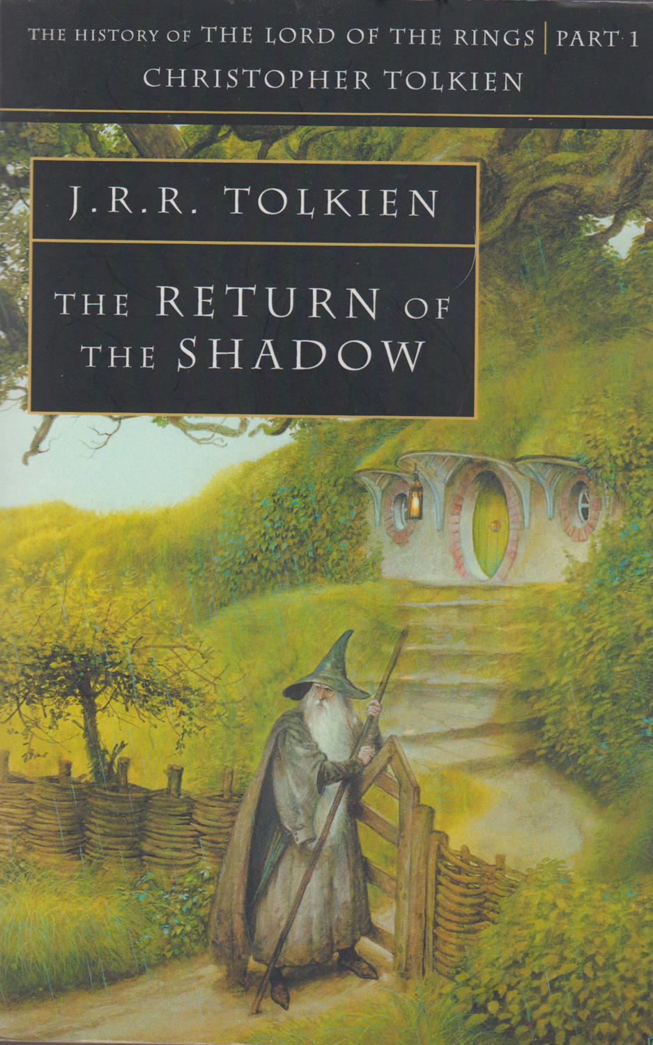
This webpage draws on the work of Tolkien's third son and his literary executor Christopher Tolkien, The Return of the Shadow. The History of The Lord of the Rings, Part 1. This is one of four volumes in which Christopher, in great detail, recorded how his father's epic work developed.
BUCKLAND IN 'THE BREWING OF THE TALE'.
"...of course in such a story one cannot make a map for the narrative, but must first make a map and make the narrative agree." Tolkien, Letter 137, to his publisher 1953.
"I wisely started with a map, and made the story fit (generally with meticulous care for distances)." Tolkien, Letter 144, to Naomi Mitchinson, proof-reader.
"If you're going to have a complicated story you must work to a map, otherwise you can never make a map of it afterwards." Tolkien speaking to Denys Gueroult, BBC Interviewer, 1964.
The frontispiece of The Return of the Shadow is a map. The copytighted original can be viewed, in colour, on the website of the Tolkien Estate. It will open in a new window and should be viewed as this webpage is perused. This is how Christopher Tolkien described it:
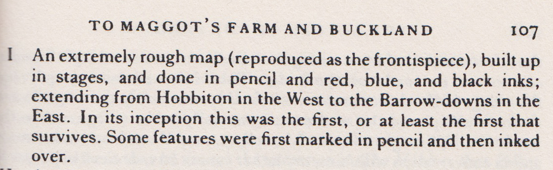
Figure 1
Christopher had earlier written:
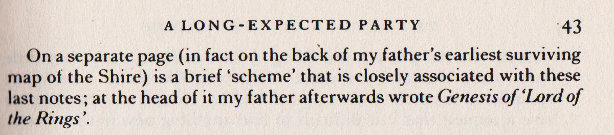
Figure 2
The entry webpage for this website shows the remarkable coincidences between a night-time drowning in the Brandywine River and a parallel event in the River Usk after a social occasion at Buckland Hall that was recorded in a local newspaper.The first mention of a 'boating accident' that led to 'Bilbo' being orphaned was originally in the second sentence of the 'Second Version' of the first chapter A Long-Expected Party that was written in late 1937 or early 1938, later emended. It is significant that Tolkien had a drowning in mind in the earliest stages of writing the sequel to The Hobbit. He later named the river where an accident occured as the Brandywine and the seat of the Master of Buckland as Brandy Hall.
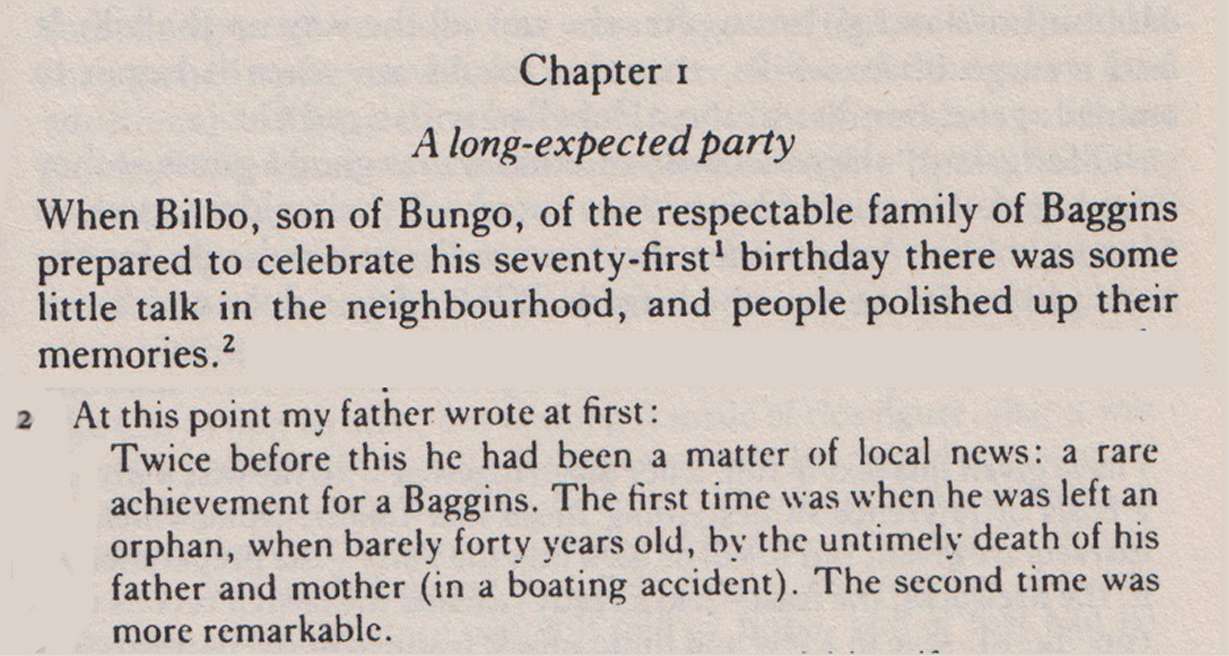
Figure 3. Extract from the 'Second Version' with Christopher's 'Note 2' appended revealing that the second sentence mentioning a boating accident had been removed. CT-19.
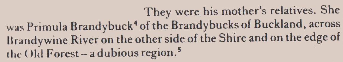
Figure 4. Extract from the 'Third Version'. First mention of the Brandywine River. 'Buckland' has replaced both Wood Eaton and Bury Underwood. Old Forest replaces Buckwood. CT-29.
The rumoured drowning accident reappears in the 'Fourth Version' of the first chapter. This was completed before 1st February 1938. 'Bingo', the son of Primula Brandybuck and Rollo Bolger was thereby orphaned, CT-37.
Commenting on his father's letter to his publisher covering the 'Fourth Version', Christopher remarks that mention of Buckland and the Old Forest in it are further hints of 'The Tale that is Brewing', CT-40.
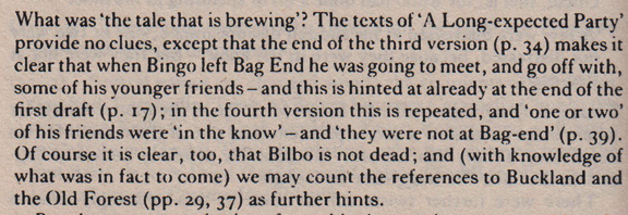
Figure 5
This shows that the name of Buckland and the adjacent Old Forest continued in Tolkien's mind as elements in the story but at first Buckland was not mentioned as a destination or a waypoint for the hobbits. In the first draft of the second chapter, identified by Christopher as From Hobbiton to the Woody End, the destination is Rivendell following the East Road. He writes 'At this stage there is no suggestion of a side road to Buckland, nor indeed that Buckland played any part in their plans'. A revised beginning of this chapter does bring Buckland unquestionably into the plot.
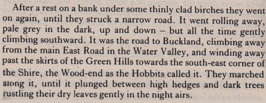
Figure 6. Revised beginning in CT's From Hobbiton to the Woody End chapter. CT-46
The route resonates in the 'Genesis' map and emphasises the importance of a map as quoted. One can imagine him later adding Hobbiton, Bywater, The Hill, the East Road, The Water, the Green Hills and Wood-end to this map to illustrate and more effectively record the journey he had already created. Also of significance is the inclusion of 'THE SHIRE' in the 'Genesis' map.
A corresponding paragraph in a further revision under Three's Company and Four's More, names Tookland and the Bywater pool in describing the route. CT-50. The hobbits continue their trek. Things turn sinister with the arrival in the story of a Black Rider; 'Buckland is still miles away', CT-55.
Following his chapter entitled Of Gollum and the Ring in which Buckland is not mentioned, Christopher continues his father's story of the approach to Buckland in To Maggot's Farm and Buckland. The turns and twists in their journey may be reflected in the sinuous track shown in the 'Genesis' map. The name Bucklebury now appears, CT-92. The curious domiciles of the hobbits are described in a passage that later was transferred to the Prologue.
In the index to The Return of the Shadow, Christopher lists the entries for Buckland first as a village then as a region. The indexing change to region takes place before the hobbits cross the Brandywine when they arrive at Farmer Maggot's, CT-94. His reasoning is given in Figure 8.
Figure 7 CT- 105
Tolkien would have had some memories of Buckland because of his visit in 1905, the premise of this website. Local parlance still uses 'Buckland' to mean the Hall and not the demesne. The 1900 postcard below illustrates this. By writing 'Buckland' he was probably reflecting how he had heard the Hall referred to years before. He would not have been aware of the shape or extent of the demesne; a map would have been necessary for this. Christopher's choice of Buckland as designating a village in the earlier pages was reasonable in the circumstances.
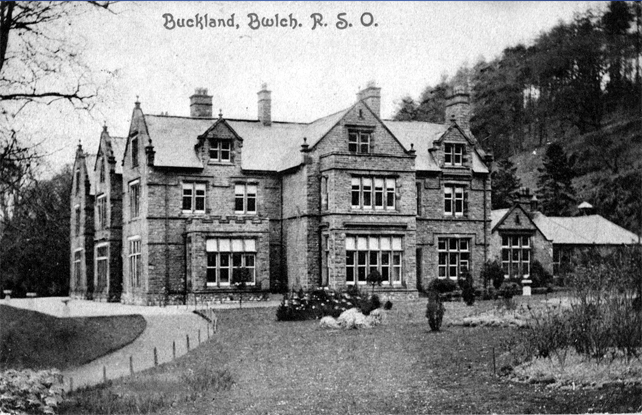
Figure 8. 1900 postcard. 'Buckland' meant the Hall
Non-Welsh visitors often mispronounce the name of the nearest village, Bwlch, as Buckle when they first encounter it, seen typically on road signs. One suspects that this Welsh spelling and various attempted pronunciations was noted by Tolkien. As Nancy Bunting observes: 'Tolkien was the master of playing with names in terms of mythology, philology, and personal associations'. (Beyond Bree, Jan. 2019). He did adopt a version of another local village, Crickhowell, as Crickhollow, a place where Frodo bought a house.
The landing stage at Bucklebury enters the story, CT-97. When they crossed the river they use many steps leading up a high bank then to pass by Brandy Hall. This ramified smial was the origin of Bucklebury-by-the River, CT-99/100.
In Fellowship of the Ring the steps were replaced by a winding path. Sometime, possibly as early as 1938, Tolkien drew the location of The Ferry in a coloured pencil drawing part of which is reproduced in grayscale below with the winding path highlighted.
Figure 9 Section from Brandywine Ferry, J R R Tolkien, Artist and Illustrator, Hammond & Scull, HarperCollins.
The change from 'many steps going up the high bank beyond' to 'the bank was steep, and up it a winding path climbed from the further landing' is significant when one refers to an OS map that shows the location of the Buckland Ferry and a winding path leading up from it. It is surmised that Tolkien had obtained an OS map of the local area when considering the further adventures of the hobbits after crossing the Brandywine. The noted Tolkienist, John Garth, in an email, observes that 'the map, with the shape of Buckland, postdates the emergence of the name'.
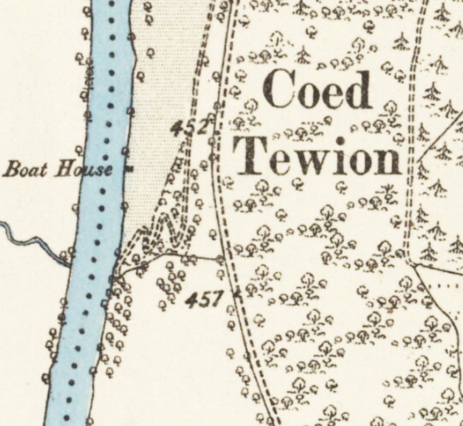
Figure 10. The location of the Buckland Ferry across the Usk.
The 'earliest surviving map' has been derived from an OS map, most likely sheets of the 6 inch series of 1905, Figure 11. The central elements, the river, the shape of the Buckland parkland, and the upstream island cannot be coincidental and provided the template, like Figure 12, on which he could position features, places and the hobbits' trek from Hobbition to Buckland that were probably been drawn in earlier sketches.
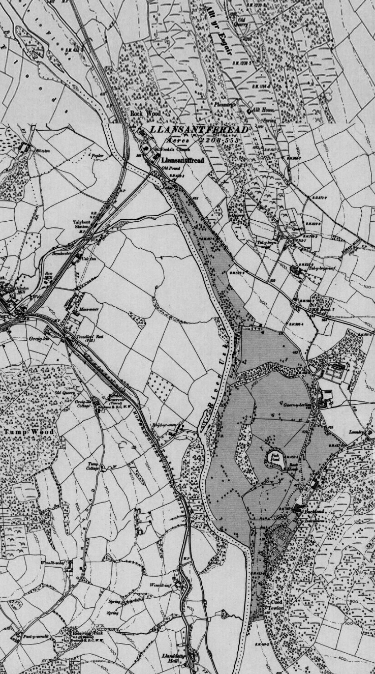
Figure 11. The Buckland parkland is indicated by the Ordnance Survey grey stippling.
The Usk River flows north to south with the Buckland parkland a bulge of land on the left bank. Its boundary was a Welsh-pleached i.e. a double thickness hedge that met the river at the North Gate. Buckland Hall is marked. A dense forest, Coed Tewion, covers Buckland Hill. An island lies upstream from the river crossings at Llansantffread (nowadays spelled Llansantffraed).
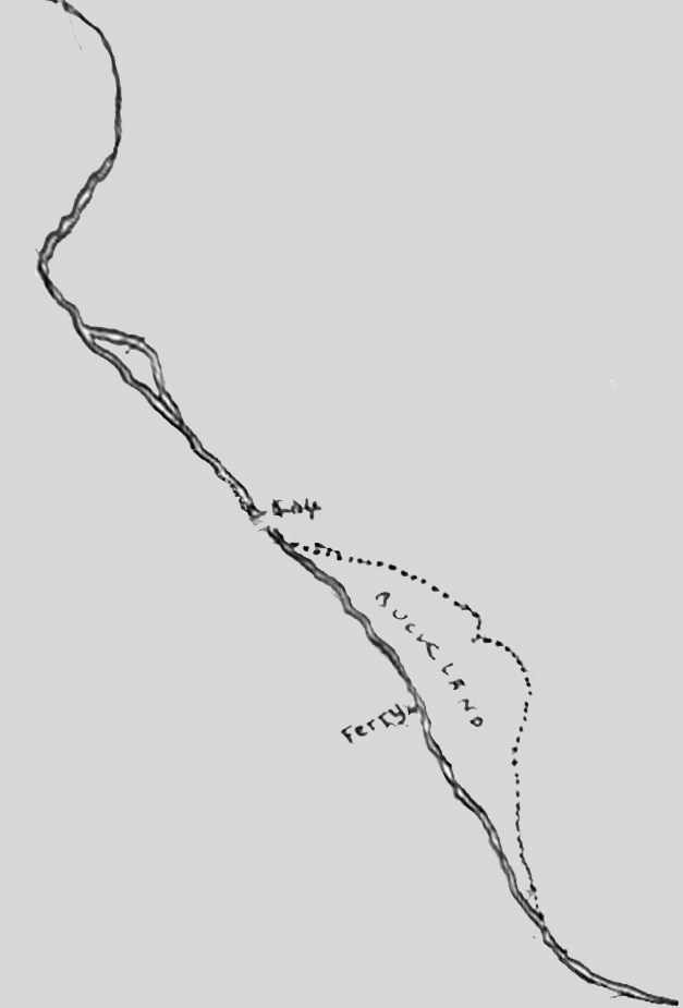
Figure 12. Central features of the 'Genesis' map.
The principal and central feature of this map is the Brandywine River. This river flows north to south. On its eastern side, the left bank, is a bulge of land named as Buckland. This land is bounded on the east by a thick defensive barrier hedge*. A bridge crosses the river at where Buckland comes to a narrow northern tip. Upstream from this Brandywine Bridge is an island, named as Girdley Island.**
*Tolkien, initially a Classics scholar at Essex College at Oxford, would have met defensive hedges in any studies of Caesar's Gallic Wars: 'The Nervii...had made these hedges present a fortification like a wall, through which it was not only impossible to enter, but even to penetrate with the eye' (2.17)
**Christoper Tolkien, in Return of the Shadow, 107, in listing the development of maps in Lord of the Rings wrote:" VI. The map which was published in The Fellowship of the Ring ; this I made not long before its publication....". This clearly points to him having either an Ordnance Survey map of Buckland, or a map closely developed from it, to hand.
CONCLUSION
It is regrettable that Buckland is not mentioned in the Tolkienography despite the part it played in the genesis of The Lord of the Rings as evidenced above. Tolkien's official biographer, Humphrey Carpenter, observed that 'several difficult issues' had been left out of his first draft. It is hard to determine what difficulty reporting a visit to Buckland in 1905 would have caused except to note that Tolkien was adamant that 'The Shire was based on rural England and not on any other country in the world (Letter 190). Of course Buckland, strictly speaking, was not in The Shire. In The History of Middle Earth (xii, 50) he did state than Buckland was to The Shire as Wales was to England.
Information about the origin of the hobbit settlement of Buckland would be found in the unpublished Tolkien papers. Those papers are presently safeguarded by non-disclosure agreements. (Testi C.A. Pagan Saints of Middle-earth. 97. Zurich: Walking Tree Publishers, 2018).
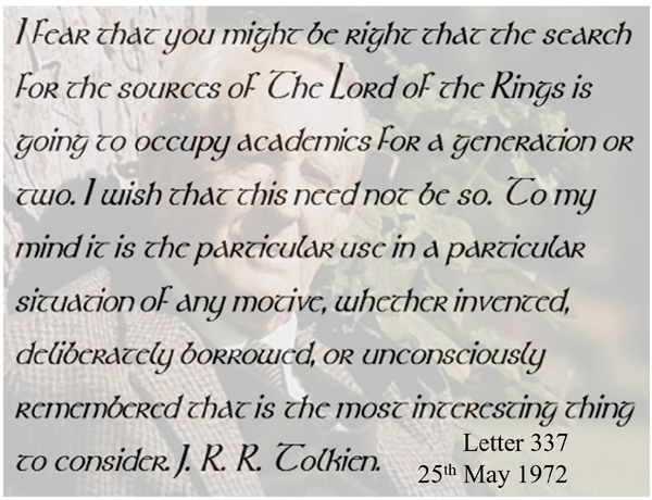
Apposite are the words from the great man himself::